Monitoring Tropical Storm Systems Following Hurricane Helene’s Impact

The National Hurricane Center is tracking three tropical storms—Isaac, Joyce, and Kirk—following Hurricane Helene’s devastating impact in the U.S. None of the current storms are expected to make landfall, although indirect effects such as rip currents may pose risks for coastal areas. Two additional disturbances are also under observation for potential development.
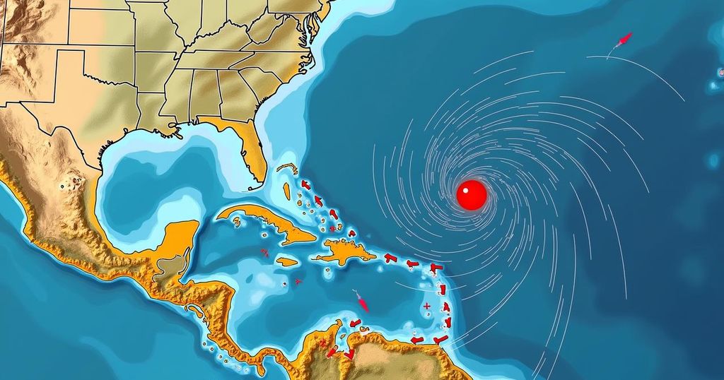
The National Hurricane Center (NHC) is currently monitoring three active tropical storm systems—Isaac, Joyce, and Kirk—following the impactful passage of Hurricane Helene. Notably, none of these storms are anticipated to make landfall in the continental United States. Hurricane Helene, which made landfall last Thursday night as a Category 4 hurricane, struck near Perry in Florida’s Big Bend region with wind speeds peaking at approximately 140 mph. The storm led to significant destruction and loss of life across multiple Southern and Southeastern states, bringing with it dangerous storm surges and torrential rainfall that placed various dams at risk. Tragically, the storm has been associated with over 100 fatalities, according to reports by the Associated Press. As the Atlantic hurricane season progresses, Isaac, Joyce, and Kirk have emerged as notable systems following Helene. The post-tropical cyclone Isaac is positioned far out at sea to the northeast of the United States, exhibiting maximum sustained winds of 60 mph. Meanwhile, Tropical Depression Joyce is to the southeast with winds of 35 mph, and Tropical Storm Kirk lies southeast of Joyce with 50 mph winds. Spaghetti models, utilized to project possible storm trajectories, suggest that all three storms will likely navigate clear of the U.S. coastal areas. Most projected paths for Isaac indicate a trajectory towards Europe, although the storm is expected to diminish in intensity before reaching land. Joyce is predicted to dissipate shortly, while Kirk is set to shift northeast towards Europe, with one model indicating a potential southwest path towards Guyana in South America. Despite the low probability of impacts from these storms on the U.S. mainland, there remains potential for indirect effects, particularly from Kirk. As National Weather Service (NWS) meteorologist Will Ulrich noted, rip currents generated by Kirk could pose risks to coastal areas some distance from the storm’s location, prompting anticipatory rip current warnings for affected regions this weekend and into early next week. While the likelihood of the three storms impacting the U.S. mainland is low, the NHC is also observing two emerging disturbances. The first, termed Disturbance 1, is noted as a disorganized area of low pressure over the western Caribbean Sea, producing thunderstorms but with a low chance of becoming a named storm shortly. Experts from the NHC estimate a 40 percent likelihood of development over the next week, with conditions possibly becoming more favorable for development as the system traverses the southern Gulf of Mexico or northwestern Caribbean Sea. AccuWeather’s lead hurricane expert, Alex DaSilva, voiced that while the system had previously raised alarm, it is less consolidated in energy now, suggesting that significant intensification into a major hurricane is unlikely. The second disturbance, identified as Disturbance 2, has a 30 percent probability of formation within 48 hours and an 80 percent chance over the next week. This system, classified as a tropical wave, is situated a few hundred miles south of the Cabo Verde Islands. The NHC predicts that upper-level winds may favor gradual development, potentially leading to the formation of a tropical depression in the coming days as it moves westward over the eastern tropical Atlantic. Notably, spaghetti models for these two disturbances are not yet available given their nascent stages.
The Atlantic hurricane season poses significant risks of severe weather, characterized by the formation of tropical storms and hurricanes. Hurricanes can result in catastrophic damage across coastal regions, as evidenced by Hurricane Helene, which recently impacted several Southern and Southeastern states, leading to extensive destruction and loss of life. The current monitoring by the NHC emphasizes the importance of tracking multiple storm systems, even when projected paths suggest they may not directly affect the U.S. Understanding storm dynamics and the potential for indirect effects is crucial for public safety.
In summary, the National Hurricane Center is actively tracking three tropical storm systems following Hurricane Helene’s devastating impact. While these storms are anticipated to steer clear of the U.S., precautionary measures, including rip current warnings, are advised for coastal areas. Two additional disturbances are under observation, with potential development noted in the coming days. Continued monitoring of these systems remains essential to ensure preparedness and safety.
Original Source: www.newsweek.com


