Understanding Ethiopia’s Earthquakes and Volcanic Activity: Insights from Geology

Ethiopia’s earthquakes and volcanic activity are rooted in geological processes spanning millions of years, particularly within the Great Rift Valley. Recent seismic events have raised concerns regarding possible volcanic eruptions at nearby sites. Scientists analyze contributing factors to forecast future activity and emphasize the importance of effective monitoring and community communication to address potential hazards.
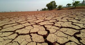
In January, a series of earthquakes and volcanic activity in Awash Fentale, located in Ethiopia’s Afar region, displaced tens of thousands of individuals. This area is part of the Great Rift Valley, which has been geologically active for centuries, marked by significant volcanic eruptions in 1250 and 1820 AD. The recent geological phenomena, continuing since millions of years ago, are seen as steps toward a future continental split and the emergence of a new ocean along the East African Rift Valley.
The cause of the trembling and potential volcanic activities stems from events that began eighteen million years ago, when continents separated to create the Red Sea and Gulf of Aden. Approximately eleven million years ago, a rift appeared beneath the Afar Depression in northeast Ethiopia, where the earth’s mantle, a hot and semi-solid layer, continues to shift. This movement forces molten rock to rise through the weak points in the crust, leading to volcanic eruptions.
As the molten rock ascends, it causes the ground to expand and eventually form a rift. This process generates friction, resulting in sudden rock breaks and the release of energy, which manifests as seismic waves. These waves create the tremors that individuals experience as earthquakes. The Afar region is noted for its high volcanic and tectonic activity, evidenced by the recent events in Fentale and nearby Dofan, indicating a history of molten materials surging to the surface.
Although no volcanic eruptions have occurred during the recent seismic events, more than 200 earthquakes with magnitudes over 4 have been documented in the past five months, featuring the strongest quake measuring 6 on the Richter scale. These tremors have inflicted damage on infrastructure, affecting buildings, roads, schools, and factories. The capital, Addis Ababa, located approximately 190 kilometers from the epicenter, felt the impacts.
The strongest earthquake recorded since 1900 occurred in 1989, with a magnitude of 6.5, highlighting the potential for significant destruction if current building standards are inadequate. The last volcanic eruption at Fentale was in 1820, and historical patterns suggest that earthquakes often precede volcanic activities, raising concerns about possible eruptions at nearby active volcanoes.
Scientists are analyzing satellite radar images from the Fentale area, discovering that recent earthquakes are likely related to hot molten rock rising from about 10 kilometers beneath the surface. The future activities may vary depending on several factors, including the molten material’s temperature and viscosity.
Three potential scenarios are anticipated under Fentale: the cooling of the molten rock leading to solidified formations, an eruption if the pressure forces materials to the surface, or the lateral movement of the molten rock potentially resulting in massive eruptions or cooling. However, unpredictable geological factors may influence these processes.
The need for improved predictive measures is pressing to mitigate future hazards. Scientists recommend employing techniques such as volcanic gas measurements, GPS monitoring, and geophysical studies, as well as fostering collaborations between researchers and governmental bodies to enhance communication with communities at risk.
In summary, Ethiopia’s seismic and volcanic activities stem from a long-standing geological evolution linked to tectonic movements in the Great Rift Valley. The recent earthquakes in Awash Fentale serve as reminders of the region’s volatility and potential for future eruptions. Understanding these processes is essential for making informed predictions and fostering community preparedness in the face of potential natural disasters.
Original Source: theconversation.com